Nomenclature: the body/system of names in a field
Why is the above relevant? Well, that’s because we’re going to be talking about nomenclature and naming convention. Lines vs. routes vs. trains, colors vs. alphabet soup, wayfinding, inbound/outbound, the hell even is an “uptown”?! Well, you name it, I’ll be sure to mention it and talk about it a little, and some of the problems a decent naming system can prevent, and a bad naming system can cause.

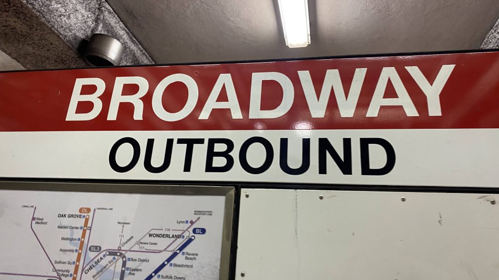
First, let’s take a look at what I’m most familiar with: the MBTA. So, the MBTA uses terms like inbound/outbound, the rainbow for subway lines (alphabet soup for the Green & Silver Lines specifically, primarily), and overall is pretty damn good with regards to wayfinding. Inbound and outbound are relative to Park St., Downtown Crossing, Government Center, and State Street (going towards these four is “inbound”, away is “outbound”). Then, there’s the Green Line. The Green (& also Silver, as it applies here too) are split into four branches: B-E. Wayfinding here is a bit gorey as all the signage will say “GREEN LINE – [TERMINAL]/PARK ST & NORTH/COPLEY & WEST”. Not exactly helpful for signage, if you were to say “go take a train signed for Heath Street” or “board a D train” – as the signs will NOT tell you this. Good wayfinding consistent with what’s on rolling stock? Well, not entirely…

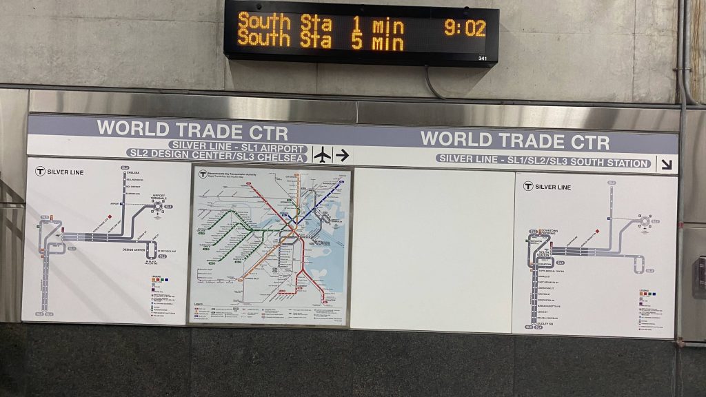
The Silver Line (at least, the Transitway), however, is different… Yeah. As seen above, not only do you have a map of the Silver Line, you also have signage WHICH TELLS YOU WHAT THE ROUTES ARE SIGNED AS ON THE BUSES AND WHERE THEY GO!!!!!! WOAH, THIS IS ACTUALLY KINDA USEFUL! On the other hand, with the Green Line also existing, this KINDA LEAVES A LOT TO BE DESIRED THERE! Like, why not have signs say “B/C GOVERNMENT CENTER”, “D UNION SQUARE” and “E MEDFORD/TUFTS” (or B BOSTON COLLEGE, C CLEVELAND CIRCLE, D RIVERSIDE, and E HEATH ST.)?!

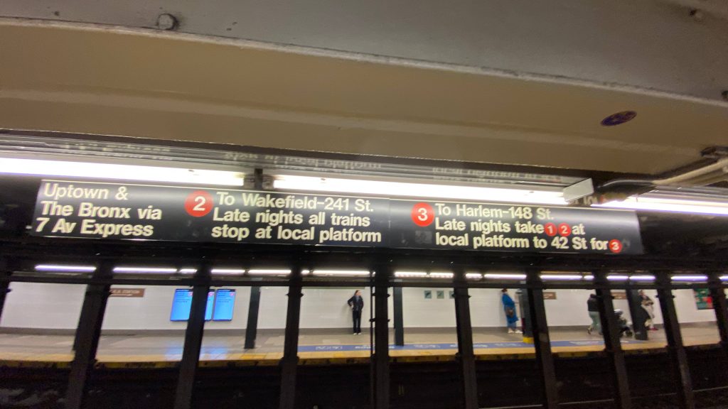
And then you have wayfinding like in NYC……. Well, to the uninitiated (like myself), it looks immensely gorey. The fuck is an uptown, the hell does all this mean, and why does the Red Line stop on many platforms?! HELP, I DON’T GET ANY OF THIS!!!! Well, chill there, little Timmy…
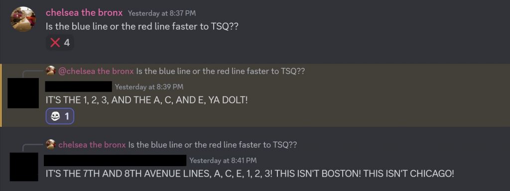
First off, it’s highly frowned upon to call subway lines by way of the rainbow in NYC. I mean, you can, but then you’ll have a case where “125th St. on the Red Line” can mean 125th & Broadway (the #1 Red Line) or 125th & Malcolm X Blvd. (the #2 and #3 Red Line). For cases like this, it’s usually prudent to just use cross-streets, or simply the service name. What’s a service? Well, think of a service like the Green or Red Line’s branches in Boston. Essentially, services in NYC are what branches are in Boston, and are more “routes” like bus routes are. Furthermore, the colors primarily refer to where in Manhattan the routes run. From left to right, north to south:
Blue: 8th Ave.
Red: 7th Ave.
Yellow: Broadway
Orange: 6th Ave.
Green: Lexington Ave.
Teal: 2nd Ave. (not currently used)
Purple: Flushing (runs underneath 42nd St. primarily)
Silver: Canarsie (runs underneath 14th St. primarily)
Brown: Nassau St.
But then you have the Crosstown Line (which doesn’t touch Manhattan at all), which is also green (but lighter green), and the shuttle lines are also in silver-grey (used for the Times Sq.-Grand Central, Franklin Ave., and Rockaway shuttles). But, whatever you do, do NOT use the rainbow, as tempting as that may be, or this might happen:

What the hell is an “uptown”? Simply put, uptown is north. Downtown, while you might be tempted to think is a synonym for “city center”, and in most cases you’d be right (downtown Boston, City Center Philly, Downcity Providence, can all be referred to as “downtown” and you probably won’t raise eyebrows out of confusion). However, use that in New York, and you’ll invariably raise eyebrows. Where IS “downtown”? Common sense might tell you “it’s near where Penn Station, Grand Central, the World Trade Center, UN HQ, etc. are”, however it’s not that simple…
Yes, there are actually MULTIPLE downtowns in NYC. “Downtown” without any place names simply refer to “south”, and “downtown Manhattan” is synonymous with lower Manhattan. However, you also have downtown Brooklyn and downtown Flushing in Queens. So, while it’s reasonable to think “downtown NYC” if you’re not familiar, just bear that in mind that most will probably default to lower Manhattan.
Back to wayfinding, what the hell does that sign mean? Well, let’s break it down. We’ve established that “Uptown” is north, The Bronx refers to, well, the Bronx, so what does the rest of the signage mean? Local tracks are the outer tracks in a 3- or 4-track setup, with express tracks being the inner tracks. So, essentially, the sign is saying “#2 and #3 7th Ave. Line stops at this platform heading north. #1 and #2 7th Ave. Line stops on local tracks during nights, change at 42nd St. for #3 7th Ave. Line”. That’s pretty much what the wayfinding sums up to. Sometimes, some routes that normally run express will run local at night or weekends, or they might short-turn somewhere before their terminus.
Other cities are relatively tame when it comes to wayfinding, like Chicago or Philly (I sadly don’t have many pictures of either), however typically NYC is considered the goriest and it’s understandable from an outsider’s POV on why that might be so. However, typically, if you need any help figuring out the gorey mess (at face value), usually Google can be of help, as are any staff that are at the station. There’s no shame in asking, and when I was in NYC I may have had to ask for a little bit of help myself.
So, how does this play into my blog? Well, I use the line name in the titles for subway stations, and rail operators for commuter and intercity rail stations. The MBTA was easy enough, as I could just simply suffix (Blue Line), (Red & Green Lines), etc. to each title where applicable. Metro-North is also easy, as I could just suffix (Metro-North) to each station, or (Amtrak/Metro-North) where applicable. But, the MTA? Each subway line is more a “route” than an actual line, as I said earlier. So, how am I handling this? Well, this poses another conundrum. For titles, usually grouping subway lines together is better for readability. I’d be more inclined, personally, to click something that read, as an example:
14th St.-Union Square (Lexington Ave./Broadway/Canarsie)
over
14th St.-Union Square (4/5/6/L/N/Q/R/W).
I mean, yeah, using alphabet soup is quicker, if I’m typing, but it’s also not really pursuant to readability. Plus, using those rules, I’d have to go back and retroactively change every Red Line station to (Ashmont/Braintree), every Green Line to (B/C/D/E), and every Silver Line stop to (SL1/SL2/SL3/SL4/SL5) or whatever is applicable. And, I don’t want to do that. So, for the sake of maintaining consistency between agencies and not pissing off the foamers in the room, I’m using the actual line name rather than the alphabet soup. And, with that, I hereby conclude my rambling on nomenclature and wayfinding.
Now excuse me, I need to go shit on the #7 Flushing Line for being overhyped (or smth, i actually don’t know what to do from here)
TL;DR: consistent naming convention is good. Wayfinding that isn’t a garbled mess or too overwhelming is good. Duplicative naming can be bad if there’s no way to differentiate.